
Importance of 3D imaging
During war, it is highly critical to have a real-time update of the ever-changing environment in order to have an advantage over the adversary. Airborne 3D imaging provides valuable information of the terrain or scene which can help provide this advantage. For example, it can be used for tactical surveillance and intelligence, bathymetry in the air or object detection. However, current topographic and hydrographic systems are unable to provide a detailed real-time update of any remote or hostile area of interest due to the high amount of data post-processing and its large physical size which requires a human-operated platform such as a piloted plane. The problem is how to make a high resolution 3D imaging technology more portable, time and cost effective in an effort to enhance sensing and situational awareness capabilities, allowing decision making superiority.
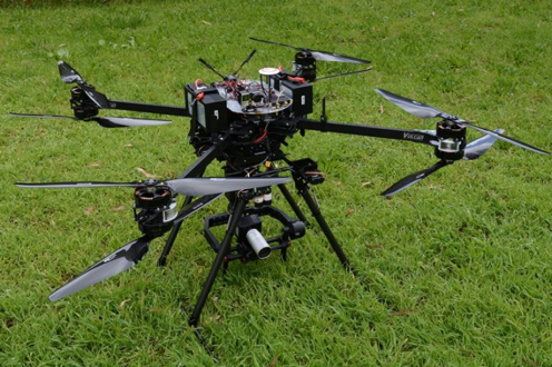
SPAD 3D Imaging UAV System

We propose to develop airborne 3D imaging system which uses a Single Photon Avalanche Diode (SPAD) array microchip as the detector. A SPAD microchip consists of an array of SPAD photodetectors which have single photon sensitivity. Each individual SPAD is accompanied by circuitry which allows the time of flight for a single photon to be measured to sub-nanosecond accuracy. This precise time measurement from each SPAD sensor in the array requires limited processing to build a 3D depth-resolved image instantaneously. This simultaneous collection of an array of data points allows 3D images to be displayed in real time, which is much faster than current scanning point to point systems.
SPAD array microchip detectors also have low size, weight and power requirements, permitting the system to be mounted onto a UAV and be remotely operated. Such a system could survey remote, hostile or rapidly changing environments and provide data in real time to key decision makers. This offers a new capability of rapid 3D data acquisition from a UAV, providing a significant military advantage in situations where quick decision making is required or when it is difficult to send in a human-operated platform.
Key Example: Limitations of Current LADS System
One key example of a current 3D imaging technology used by Defence is the Laser Airborne Depth Sounder (LADS) system, which is designed to perform 3D surveying of coastal areas to obtain bathymetric and topographic information. This information can be used for amphibious craft navigation, or for deploying personnel when they reach the shore.
Current LADS systems use a single point Laser Detection and Ranging (LADAR) scanning system, requiring significant scanning times and subsequent data processing times. Large size, weight and power requirements of the current system means a small, piloted purpose-fit aircraft is required with a certified operator on-board to survey the area of interest. This all adds to operating and maintenance costs, long preparation times, the need to have nearby airports available, and a communication (internet or courier) to send the collected data back to relevant agencies for processing.
It is clear current methods make it impractical to survey remote areas, or be used for rapid assessment and data collection when in hostile, contested or rapidly changing environments. This poses a major capability gap for Defence operations, causing current key operation decisions in such circumstances to be made with a lack of relevant data.
How SPAD 3D Imaging UAV System offer better solution (also known as SPAD LADS for this application)
Please note: SPAD LADS is the name of the SPAD 3D Imaging UAV System used for the LADS Application
The high density SPAD array detector within the 3D imaging system provides three key advantages:
- Low SWaP requirements: it allows the SPAD-based 3D imaging system to be mounted onto a remotely operated UAV which can be deployed at any time to perform rapid assessment
- Single photon sensitivity of the SPAD array detector: this allows the system to operate at large stand-off distances or at low light conditions.
- Rapid acquisition rate: this allows a high coverage area because of the detector’s high-frame rate and simultaneous collection of 1000s of data points.
Hence this UAV-based system could be sent out for littoral mapping when information about the seafloor or detection and recognition of objects in the water is required in real-time for the safe navigation through hazardous or shallow waters.
Other applications
The ability for the remote operation of this 3D imaging system makes it ideal for improving rapid environment assessment and data collection applications within Defence.
One such application that takes advantage of the single photon sensitivity of the SPAD detector is the topographic imaging through obstructions such as foliage. This would be useful for safe and efficient land operations in unknown or hidden environments. Due to the system’s low SWaP requirements, another application could be the installation of the SPAD 3D imaging on a land vehicle to survey the vehicle’s surroundings. Combining the system’s ability to image long distances with its rapid acquisition rate makes the system ideal to detect any adversaries or obstacles in rapidly changing environments.
We believe there are many more applications that are we have not explored and would appreciate an opportunity to speak with ADF members that are interested in our system for their operations.
What we are looking for
- Collaborate with relevant Navy Capability to develop the SPAD 3D Imaging UAV System for LADS application
- Meet with personnel that are interested in using the SPAD 3D Imaging UAV System for their operations
About the authors
Nicola Bilton is a research scientist at the Defence Science and Technology Group. Nicola joined DST Group as a student cadet while completing a BSc(Hons) in Physics at The University of Adelaide, majoring in both Experimental and Theoretical Physics. After graduating, she transitioned into her current role as a research scientist working in the advanced sensors discipline. Her research has largely involved developing and investigating SPAD-based long range 3D imaging systems, which includes extensive characterization and assessment of the performance of the SPAD array sensors and performance testing of various systems.
Joyce Mau is a research engineer at the Defence Science & Technology Group. She holds a BEng(Hons)/BSci from The Australian National University majoring in Electronics and Communications Systems and Mathematics. She joined DST Group on a student cadet scholarship and for her Honours research, she implemented detection, recognition and tracking algorithms in GPU to analyse Single Photon Avalanche Diode (SPAD). Her current research continues to develop and improve the algorithmic capability.